
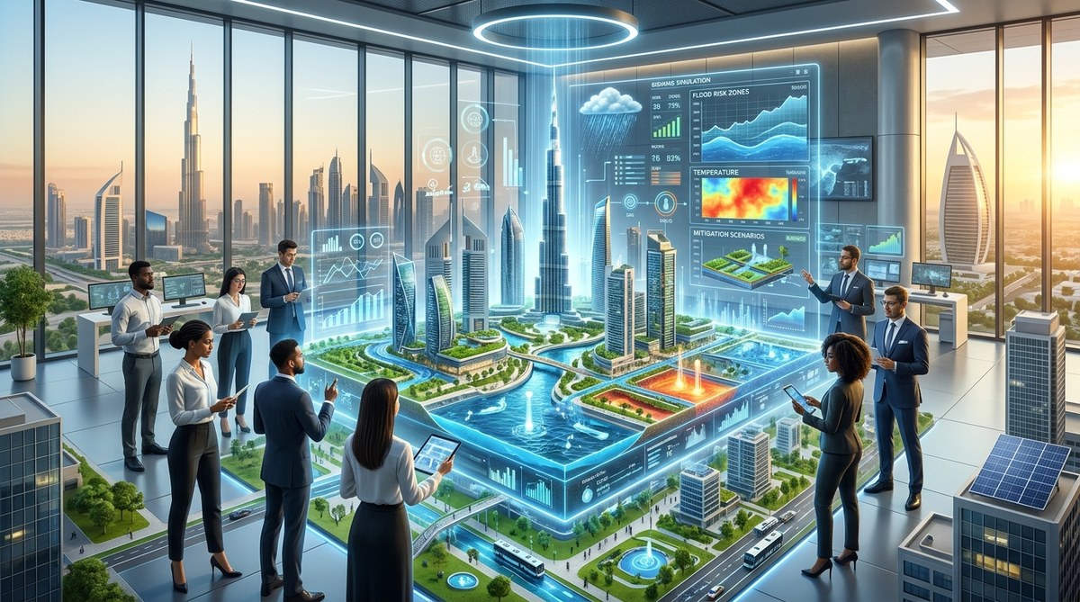
Picture a city that can test a hundred year storm before it happens. A city that reroutes floodwater, adjusts building codes, and plants shade trees in a virtual sandbox before spending a single dollar on concrete. That is not science fiction. That is how smart city planners are using digital twins for climate adaptation in 2026.
A digital twin is a living, breathing copy of a physical place. It pulls data from sensors, satellites, and traffic feeds. It learns. It predicts. And for urban planners who are tired of reacting to disasters, it is the most powerful tool in the shed. Instead of waiting for a flood to test a drainage upgrade, you run the simulation tonight. You see the problem. You fix it. Then you sleep better.
Digital twins let urban planners run climate scenarios before disasters strike. By combining real time sensor data with predictive modeling, cities like Miami, Rotterdam, and Singapore are testing flood defenses, heat mitigation strategies, and infrastructure upgrades in a risk free virtual environment. This saves money, protects lives, and builds resilience faster than traditional planning ever could.
Why digital twins matter more now than ever
Climate change is not a future problem. It is a 2026 problem. Coastal cities face rising seas. Inland cities bake under longer heat waves. Stormwater systems designed for the twentieth century fail under twenty first century rain.
Traditional planning relies on historical data. That is like driving by looking in the rearview mirror. A digital twin, on the other hand, uses live data and predictive algorithms. It shows you what will happen next Tuesday, next year, and in 2050. You can test a green roof program, a new seawall, or a zoning change and see the impact within hours.
Consider Miami Beach. The city has spent hundreds of millions on pumps and raised roads. But planners also built a digital twin of the entire island. They can simulate a king tide combined with a summer thunderstorm. They see exactly which streets flood first and how long the water stays. That information guides every new infrastructure dollar.
How planners build climate scenarios with digital twins
Building a useful climate simulation is not magic. It follows a repeatable process. Here is how smart city teams do it in 2026.
-
Collect the data layer. Start with elevation maps, drainage networks, building footprints, and soil types. Add live feeds from rain gauges, tide sensors, and temperature stations. The more granular the data, the better the twin.
-
Calibrate the model against past events. Take a known flood or heat wave. Run the digital twin backward. If the model produces the same damage patterns, you know it is accurate. If not, adjust the parameters until it matches reality.
-
Define the climate scenarios. Use the latest IPCC projections or local climate studies. Choose three or four scenarios: a ten year storm, a fifty year storm, a heat wave lasting two weeks, or sea level rise of two feet. Each scenario becomes a separate simulation.
-
Run the simulations and measure impacts. Watch the water rise. Watch the temperature climb. The twin shows which neighborhoods flood, which buildings overheat, and which roads become impassable. It quantifies damage in dollars and disruption in days.
-
Test interventions in the twin. Add a rain garden here. Raise a road there. Change the zoning to require cool roofs. Rerun the same scenario. Compare the results. Keep the interventions that work best.
-
Update the twin continuously. A digital twin is not a one time project. As new buildings go up, as the climate shifts, and as sensors collect more data, the twin gets smarter. Schedule quarterly updates.
What a good climate twin looks like
Not all digital twins are created equal. Some are glorified 3D maps. Others are true predictive engines. The table below breaks down the difference between a basic model and a high fidelity climate twin.
| Feature | Basic 3D model | Full climate digital twin |
|---|---|---|
| Data sources | Satellite images, GIS layers | Real time IoT sensors, weather feeds, traffic data, tide gauges |
| Update frequency | Static or yearly | Live or daily |
| Scenario capability | Pre rendered flythroughs | User defined climate scenarios with adjustable parameters |
| Outputs | Pretty pictures | Damage estimates, risk maps, cost benefit ratios, intervention rankings |
| Integration with planning | Standalone presentation tool | Connected to permitting, capital planning, and emergency management systems |
A full climate twin is not cheap, but it pays for itself. The city of Norfolk, Virginia, used its twin to avoid building a new pump station in a location that the model showed would flood again within five years. That single decision saved taxpayers more than the cost of the entire twin project.
Tools and techniques that power climate twins
Planners use a mix of off the shelf platforms and custom code. Here are the most common building blocks.
- IoT sensor networks. Water level sensors, soil moisture probes, and air temperature stations feed the twin with real world data. Without them, the twin is just a guess.
- Hydraulic and hydrodynamic models. Software like EPA SWMM, TUFLOW, or HEC RAS simulates how water moves across streets, through pipes, and into waterways.
- Urban energy balance models. These simulate how heat moves through buildings, pavement, and vegetation. They help planners test cool pavement coatings, tree canopy expansion, and green roofs.
- Machine learning for pattern detection. Algorithms learn from past events to predict future hotspots. For example, a twin in Austin, Texas, uses ML to predict which low lying intersections will flood during a one inch per hour rain.
- Digital twin platforms. Companies like Cityzenith, Bentley iTwin, and Autodesk offer platforms that combine visualization, simulation, and collaboration tools. Many cities build their own using open source geospatial libraries.
“A digital twin is not a deliverable. It is a decision making habit. The cities that succeed are the ones that run simulations every week, not just when a grant requires it.” – Dr. Marisol Vega, urban resilience researcher at Georgia Tech
Common mistakes and how to avoid them
Even the best technology fails without good process. Here are the pitfalls that trip up smart city teams.
- Garbage in, garbage out. A twin is only as good as its data. If your elevation map is five years old and missing new developments, your flood model will be wrong. Audit your data before you build.
- Ignoring social data. Flood risk is not just about water depth. It is about who lives there. Do residents have cars to evacuate? Do they speak English? Do they have savings? A twin that ignores equity will recommend solutions that hurt the most vulnerable.
- Building a twin without a question. Some cities build a digital twin because it sounds cool. Then they have a beautiful model and no idea what to do with it. Start with a specific question: “Should we raise Main Street or build a detention pond?” Then build the twin to answer that.
- Forgetting to update. A twin that is not maintained becomes a digital ghost. Assign a team to keep sensors running, data flowing, and models calibrated. Budget for this from day one.
- Siloing the twin. If only the GIS team can use it, the twin is wasted. Give planners, engineers, emergency managers, and even city council members a simplified view. The more people who ask questions of the twin, the better the decisions.
Real cities, real results
Let us look at three cities that are using digital twins for climate adaptation right now.
Rotterdam, Netherlands. The city built a twin of its entire water system, including canals, pumps, and green roofs. Planners simulate extreme rainfall and see exactly where water will pond. They use the results to prioritize green infrastructure projects. The twin also shows how much water each green roof can absorb, helping the city target subsidies to the most effective locations.
Singapore. The island nation uses a twin called Virtual Singapore. It models wind flow, solar radiation, and heat distribution across the entire city. Planners test building orientations and facade materials to reduce the urban heat island effect. The twin helped redesign the Marina Bay district to stay cooler during afternoon peaks.
Helsinki, Finland. Helsinki built a twin of its energy grid and building stock. They simulate how a heat wave will drive up air conditioning demand and strain the electrical system. The city uses the results to plan backup power for hospitals and cooling centers. The twin also models the impact of adding district cooling to new developments.
How to start your own climate twin project
You do not need a billion dollar budget. You need a clear question, a willing partner, and a willingness to iterate. Here is a starter checklist.
- Pick one climate risk. Floods, heat, or sea level rise. Do not try to model everything at once.
- Choose a small geography. A single watershed, a downtown district, or a vulnerable neighborhood. Prove the concept before scaling up.
- Find existing data. Your city already has elevation models, stormwater maps, and building footprints. Start with what you have.
- Partner with a university. Engineering and computer science departments often have students who can help build and calibrate the model. It is low cost and high value.
- Run one simulation. Pick a real storm from last year. See if the twin matches what happened. Adjust. Then run a future scenario.
- Share the results. Show the twin to community groups, city council, and local media. Build support for the interventions the twin recommends.
For more on how data analytics supports these kinds of decisions, read our guide on harnessing data analytics for smarter urban infrastructure design. And if you are curious how green building technologies fit into the picture, check out the future of sustainable cities through green building innovations.
Building a culture of simulation
The most important shift is not technical. It is cultural. A digital twin changes how a city makes decisions. Instead of arguing about opinions, planners argue about model outputs. Instead of waiting for a disaster to prove that a seawall was needed, you have the proof in advance.
That takes trust. Planners need to trust the data. Politicians need to trust the model. Residents need to trust that the city is spending money wisely. The best way to build that trust is to start small, show results, and let the twin speak for itself.
In 2026, the cities that adapt fastest will not be the ones with the most money. They will be the ones that learn fastest. Digital twins are the fastest learning tool we have. Use them. Test everything. And build a city that can handle whatever the climate throws at it.
For a deeper look at how smart city policies are reshaping resilience, see our article on 6 smart city policies that are redefining urban resilience in 2026. And if you want to understand how IoT sensors feed these models, read how to leverage IoT sensors for real-time urban infrastructure monitoring.
The future of urban planning is not a blueprint. It is a simulation. Start running yours today.

Leave a Reply